|
|
Oasis of Chinguetti |
Protected Area |
|
 |
|
The Country |
|

|
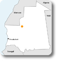
Mauritania, situated between Morocco and Senegal, is covered for two thirds of its territory by the Sahara desert. It has less than 3 million inhabitants, mainly living on agriculture and goat and camel breeding. Today it is a poor Country, although it had been for centuries the land of nomadic people, characterized by the great routes linked to the transaharian trade and by the caravans loaded with salt and spices. It was the Country of "the wise Bedouins", as its inhabitants like to be called still today, because already at the beginning of the second millennia the Mauri tribes had created schools, collected libraries, gathered Arabic and European intellectuals to elaborate "the thought of the desert": a symbiosis and a pact of mutual benefit between man and the Sahara was born.
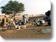
The Land of Men, as Saint Exupery, the author of The Little Prince, called it in the early 20th century. Mauritania is the country where the plane of The Little Prince has an emergency landing, and it's from those sand dunes that the child talks about his love for a unique and lonesome rose. Today, large-scale nomadism has disappeared, transaharian trades have been replaced by new, modern, and fast trade opportunities, and the ancient manuscripts have been collected in the public and private libraries of the historical towns and the capital. Chinguetti preserves about 3,000 volumes: almost as many as its inhabitants! Many of these volumes, if sold, would yield interesting sums for their owners (however, their sale is forbidden both by the traditional law and the penal code), but their real value is represented by the fact that they witness such a deep cultural identity that cannot even be replaced by the difficulties of the everyday survival. Poverty, water shortage, the dunes invading the palm groves and the huge acacia trees with their roots out of the ground, as if they were leaving towards less dry lands, are the characteristic environmental features of Chinguetti plateau. The inhabitants vary from 4,000 to 6,000 according to the season, since nomadism linked to breeding activities is still practiced: the families abandon the plateau during the dry season and lead the cattle - goats and camels - to graze towards the South. Besides breeding activities, local economy also includes the production of dates, which are sold also throughout the Country, and, more recently, tourism. The oases in the Municipality of Chinguetti represent an ideal stop for many migratory birds spending the winter in Africa and moving to Europe in spring, across the Sahara. Among them, the black stork, particularly appreciated by the local people because its passage forecasts the arrival of the rainy season. However, migratory birds are more and more endangered, because desertification has considerably reduced the environmental resources: it is difficult to find water and food in the middle of the Sahara. |
The Region Involved |
|
| Chinguetti plateau, at about 450m asl, covers an area of about 16,000 km2 and includes the Municipalities of Chinguetti, Ouadane, and Ain Savra. An asphalt road and some tracks not easily accessible also by all-terrain vehicle connect Chinguetti with Ouadane (another oasis of considerable historical importance) and with Atar, the main town of the region; vice versa there are no connections between the municipal main town and the various oases of its territory, even 60 km far from the town and accessible by all-terrain vehicle (it takes one day to reach them). The area is characterized by a saharan / sahelian climate, with a medium rainfall amount (55mm calculated in the latest 10 years). Temperatures are high, reaching 50° in June and July; however, the minimum night temperature in January and February can be close to 0° C. The potential evaporation is high, assessed in over 3,000mm/year. The plateau is slightly inclined from the west to the east and from the north to the south; it is crossed by several wadis (valleys, also called "oued"). The dunes move fast because of the almost constant winds that, except in the period between October and December, come from north and north-east. The phenomenon is evident in the palm groves, gradually covered with sand. Some aerial shots of the 1950s show an area of about 120 ha covered with palm groves: today this area is less than a half. Drought, influencing these regions in the latest decades, has eliminated most of the traditional incomes. 75% loss in cows, 30% in small ruminants, and 25% in camels, besides the loss of agricultural yield in the oases. The soil of the plateau is at the same time rocky and sandy, with alluvial and wind deposits alternating with rocky areas characterized by a scarce organic substances. Where rain stagnates thanks to the presence of basins and natural depressions, it is possible to find rather fertile clayey-sandy soils, suitable for cultivation. Rainfalls, torrential when they come, rapidly flow on the soil with few possibilities to penetrate, washing out and impoverishing the surface. The main arboreal species growing on the plateau are Acacia tortilis, Capparis decidua, and Tamarix senegalensis, together with Maerua crassifolia and Boscia senegalensis. The pastures mainly consist of Panicum turgidum, while near the backwaters it is possible to find species like Ficus gnaphalocarpa. In the sandy ergs in the east of Chinguetti, Aristida pungens and Leptadenia pyrotecnica grow only in permanent dunes, while in the reg of the plateau Acacias flava and Balanite aegiptica grow. The mixed rocky and sandy soils are populated by Panicum turgidum and sometimes Euphorbia balsemefera; the rocky soils are dominated by Acacia flava and Ziziphus lotus. The most practiced activities are agriculture and breeding, alluvial cultivations, and the horticulture practiced under the palms. Breeding activities include goats-sheep and camels. The animal pressure is constant and creates a situation of over-exploitation of the pastures, leading to a reduction and even disappearance of the vegetable covering. This phenomenon is worsened by the use of wood as kitchen fuel. The environment is becoming more and more fragile, endangered by deterioration: the vegetation has continuously reduced in the last 30 years, wildlife is endangered, or has considerably reduced. The land property has always been - and still is - a joint property. Each tribe, or part of a tribe, has its own territory, and the various families are entitled to cultivate parcels of land considered as a traditional property, as well as to build on these parcels. There are no certificates stating land property. However, the property is rarely disputed and, in case of dispute, the traditional chiefs are going to solve it, while only in extraordinary cases it is necessary to turn to the administrative authority. Thanks to oral agreements (which are very respected), the tribes that do not own the land can use, in case of need, someone else's land. Everything depends on water in the desert: it is the main and essential resource for any form of human, animal, and vegetable life. Only in extremely dry environments like this it is possible to understand the importance of the water resource and, without a doubt, only in dry places this resource is used responsibly, with no waste. |
|
The Project |
|
| In our case, the black stork has played its role very well and, according to the tradition, has committed itself to bring water to the people welcoming it during its migration. Monte Fenera Park has welcomed the request by the Mayor of Chinguetti to carry out surveys near one of the passage sites of the stork (Leghlaveh site, a stop for migratory birds, but also for nomadic families, about three/four hundred people) aiming at the discovery of the water table enabling the excavation of a well to use for both men and animals, as well as at the cataloging of the still existing autochthonous vegetable species. The survey was necessary and preliminary to the creation of the well, for which the Municipality of Pray (Province of Biella) committed itself. The synergy between the two Authorities, together with the contribution given by Regione Piemonte, has given the opportunity to meet the vital needs of the small community and, parallelly, to improve the areas where the black storks stop so that, increasing the number and size of the ponds, they might have more possibilities to overcome the traverse of the Sahara. The activities on the spot have been implemented by the non-profit institution Onlus Terre Solidali from Piedmont, whose members and collaborators have been working for years in Mauritania and in the North African and Sahelian Countries: they have exploited local collaborations and acquaintances in order to optimize the available resources. Monte Fenera Park contributed to carry out a geophysical study entrusted to a small enterprise from Mauritania, that has enabled to find out the exact location of the water table. Moreover, a local sensitization campaign addressed in particular to schools has been started to strengthen the concept of protection and safeguard of the environmental resources. Thanks to the collaboration of an Italian researcher, local vegetable species (trees and shrubs) have been recorded and photographed, and the use of some species in the field of medicine has been discovered. In particular, we have obtained information on berries and roots useful in the field of the traditional animal medicine. |
|
The Role of the Municipalities |
|
| The ongoing democratization process in Mauritania is based among the other things on the possibility to transfer part of the state powers to the decentralized public institutions, first of all the municipalities: as a consequence, the latter are starting to play a significant role in the ongoing development process of the Country.
Each Municipality covers a very large territorial area - too large even for a big Country like Mauritania - and gathers several far locations (from one location to the other it often takes half a day by all-terrain vehicle). In the case of Chinguetti, the Municipality manages very fragmented nuclei with 50 to 700 inhabitants. The various villages are represented in the Municipality by an appointed Town Councillor, and this is essential to give the Municipalities the opportunity to get to know the local problems and coordinate the resources. |