 |
- Government: Republic
- Independence: 3/8/1960 (from France)
- Area: 1,186,408
- Population: 9,849,596
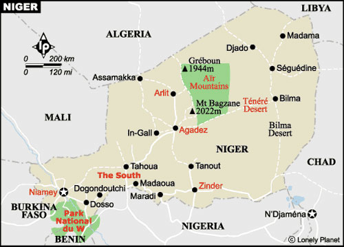
- Capital: Niamey
- Other towns: Agadez, Diffa, Dosso, Maradi, Tahoua, Tillaberi, Zinder
- Currency: CFA franc (1 Euro = 655.00 CFA francs)
- Language: French (official), used also Hausa, Djerma, and Tamachek languages spoken by Tuareg, Poular spoken by Fulbe, Kanuri, and other local languages
- Ethnic groups: Hausa 53,6%, Djerma 21,2%, Fulani 10%, Tuareg 9%, Kanuri 4,3%, other 1,9%
- Religion: Muslims 98,7%, animists 0,7%, Christians 0,4%
- Time zone: -1
- Average annual temperature: 29,1°C
- Days of rain: 42
- Agricultural resources: millet, sorghum, rice, peanuts, cotton, gum arabic, onions
- Breeding: cows, sheep, goats, camels
- Mining resources: uranium, cassiterite, carbon, iron, manganese
- Population growth rate: 3.3% per year
- Infant mortality rate: 123/1000 inhabitants
- Life expectancy: 47 years
- Illiteracy: 72%
Culture
The Hausa are a clearly different ethnic group as far as linguistic identity is concerned. Over 20 million West Africans say "good morning" in Hausa as if it was natural, and as many of them speak it as a second language, to the extent that it is one of the most widespread languages in Sub-Saharan Africa. The ancient Hausa culture originated in the heart of northern Niger and then spread throughout the rest of the Country. Other ethnic groups are the nomadic tribes of Fulani and Tuareg. The Borro Fulani, or Wodaabé, are also called the "people of taboos", for their entangled and exhaustive set of taboos and moral codes emphasizing their confidential nature and unpretentiousness, patience and strength of mind, caution, foresight, and hospitality. History has not been very generous with the Tuareg: once proud lords of the desert, today we can find them piling up bricks in the building sites or working in the mines, while the rebels conceal themselves in the mountains fighting for survival.
The Inadan, extraordinarily skilled craftsmen, live in a sort of vassalage or servitude with Tuareg. They are not employees, but are appreciated for their skill in silver working and in the manufacturing of saddles, bags for camels, tools, and talismans. Among the objects created by the Inadan, the Croix d'Agadez is particularly interesting: it is a silver filigree cross which is a powerful talisman protecting against the evil eye. For this kind of object and other silver objects, the noble Tuareg offers gifts and, should he not show indulgence towards who served him, an evil juju could hit him and his family. It is a very delicate and paradoxical relationship in which both master and slave belong to the highest social sphere, but one depends on the other for mutual respect, social position, and survival. The Inadan are known as malicious people "older than memory, proud as the crow, mischievous as the wind", and can cast spells, tezma or ettama, as acts of retribution against those who have gone beyond the invisible line of respect they require.
You will not easily remember the Niger cuisine. In the north, most of the meals consist of some combinations of yogurt, rice, and lamb, while in the south they consist of rice, sauce, couscous, meat sauce or stew. However, you may appreciate the dishes for the particular atmosphere Niger can offer you: everything seems better if eaten under the stars of with your feet in the hot sand.
Environment
Niger has no access to the sea, and lies at more than 650 km from it. It borders in the north with Algeria and Libya, in the east with Chad, in the south with Nigeria and Benin, and in the west with Burkina Faso and Mali. Two times larger than France, Niger is the second largest Country of western Africa, but one of the least populated Countries, with the 90% of the inhabitants living in the south, in the Niger valley, far from the desert of the north. It is covered for about two thirds by the desert and for one third by Sahel (the semi-desert area in the south of Sahara). Only a limited area in the south receives water enough for the crops. The desert is continuously advancing, and there is the risk that one day the Country can disappear under an expanse of sand. In Niger, the water supplies are limited, and the river Niger only crosses a small area of the Country bordering with Mali, Burkina Faso, and Benin.
The fast desertification of Niger is due to several factors: the devastating drought periods of the 70s, the excessive exploitation of the grazing lands, the cutting of trees to obtain firewood, and the sand characterized by a great quantity of pure quartz which makes it difficult to use the soil and impoverishes the crops. The situation is particularly serious in the north and center of the Country, while in the south the survival of the wildlife populating the national park - hippos, giraffes, elephants, buffaloes, and leopards - depends on the waters of the river.
Generally, Niger can be as sultry as or more than hell, with average temperatures of about 30°C, which can go beyond the 50°C in the hottest season (between March and June). During these months, the climate is so torrid that rain evaporates before touching the soil. The coolest period goes from December to February, with night temperatures in the desert below zero. Before the rains, the harmattan wind starts to blow and brings a thin and dusty fog surrounding everything. The rainy season, usually going between June and October, can create difficulties if you travel.
|
|
- Government: Presidential Republic
- Independence: 1/8/1960 (from France)
- Area: 112,622
- Population: 6,787,625
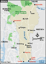
- Capital: Porto-Novo
- Other towns: Natitingou, Cotonou, Parakou, Lokossa, Porto-Novo, Abomey
- Currency: CFA franc (1 Euro = 655.00 CFA francs)
- Language: French (official), also used local languages: Fon, Gu, Yoruba, and others
- Ethnic groups: Fon 39%, Yoruba 12%, Adja 11%, Houeda 8,5 %, Bariba 8%, Fulani 5,5%, others 16%
- Religion: animists 61%, Catholics 21%, Muslims 12%, Protestants 2,3%
- Time zone: -1
- Average annual temperature: 26,7°C
- Calling code: 00229
- President: Mathieu Kérékou
- Agriculture: cotton, cocoa, manioc (tapioca), cereals, peanuts, palm
- Breeding: sheep, goats, pigs
- Industry: fabrics, building materials, chemical products, crude oil
Culture
Benin is characterized by a rich culture, and for over a century its traditional artistic production has attracted the attention of the entire world. According to the traditional culture, art should tend to a spiritual purpose, but during the period of the Fon kings, craftsmen were encouraged to create objects evoking the heroic features and the prestige of the kings. The history of this period was told on colored tapestry, of which it is still easy to find modern examples. The bronze objects made in Benin are universally known among collectors, even if their quality is no longer similar to the quality characterizing them in the past. According to the legend, the art of melting bronze was hindered by an Ife leader who got angry because of a bronze statue representing his predecessor and established the death penalty against the people using this material. After many centuries, it seems that the decree is still in force. The bas-reliefs of Abomey palace have been declared a World Heritage Site by UNESCO.
In Benin there are several kinds of popular dances, some religious and others not. Some of them are characterized by group choreographies, but most of them are individual and incredibly expressive. People usually dance during specific celebrations like "La Gani", celebrating culture and identity, but also during spontaneous forms of celebration. The life extolling ceremonies of the dancers are one of the most fascinating features of the Country.
The cultural feature of Benin which most attracted the interest of the world is the voodoo, an animistic religion practiced by almost the 70% of the population, which believes in the relationships between the human world and the world of spirits: in other words, they believe that spirits are present in all things.
Environment
Benin is situated in western Africa and covers an area of 112,620 square kilometers. The Country is a long strip of land perpendicular to the coast of the Gulf of Guinea. It borders in the north with Burkina Faso and the Republic of Niger, in the east with the Federal Republic of Niger, and in the west with Togo Republic. The southern coast is 124 km long and the greatest north-south distance is of 672 km, from the river Niger to the Bay of Benin. Its size equals the two thirds of Portugal, and it is a little smaller than Pennsylvania.
The Country is divided in five natural regions: the coastal area, the plain called "la terre de barre", the plain covered by the trees of the savannah, a north-western hilly region (Atakora), a water supply for Benin and Niger, and the fertile lands of the north-east. In the south, along the coast, there are boundless plantations of palms and coconuts.
|
|
- Government: Presidential Republic
- Independence: 5/8/1960 (from France)
- President: Captain Blaise Compaoré
- Area: 274,400
- Population: 10,312,609 (census 1996)
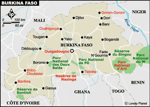
- Capital: Ouagadougou
- Other towns: Kongoussi, Kombissiri, Dièbougou, Tenkodogo, Koudougou, Banfora, Zorgho, Bogandè, Fada N’Gourma, Bobo-Dioulasso, Ouagadougou, Orodara, Nouna, Koupèla, Dèdougou, Po, Boulsa, Ziniarè, Gorom-Gorom, Yako, Gaoua, Reo, Kaya, Dori, Leo, Djibo, Tougan, Diapaga, Ouahigouya, Manga
- Currency: CFA franc (1 Euro = 655.00 CFA francs)
- Language: French (official), Malinke, More
- Ethnic groups: Mossi 48%, Fulani 10%, Bobo 7%, Lobi 7%, Mande 7%, Senufo 6%, others 15%
- Religion: Muslims 50%, animists 40%, Christians 10%
- Time zone: -2
- Average annual temperature: 26,4°C
- Days of rain: 59
- Agriculture: cotton, peanuts, sesame, sorghum, millet, cereals, rice
- Industry: soap, mineral waters and beer, cigarettes, fabrics, gold
- Infant mortality rate: 123/1000
- Life expectancy: 49 years
- Illiteracy: 80%
Culture
In Burkina Faso there are more than 60 ethnic groups with different social and cultural features, even if they all want to be called Burkinan. The main groups are the Bobo, living in the town area of Bobo-Dioulasso, Fulani, Lobi, and Senufo, but the dominating group is represented by Mossi. The Mossi descend from a royal empire and the emperor, or moro-naba, plays an important role and has a great social influence. Some descendants of the Mossi are Muslims; however, Burkina Faso is one of the few Countries of western Africa to have a non-Muslim majority, since most of the population still follows the traditional animistic beliefs.
Each ethnic group is characterized by its own art, but the artistic traditions of the Mossi, Bobo, and Lobi are the most famous. The Mossi are known for their red and white incredibly high antelope masks (over 2 meters). These masks are worn during funerals and during gathering and conservation activities regarding some fruits. The masks made by the Bobo are butterfly-shaped masks, painted with red, white, and black stripes, and are used to invoke the divinity Do during fertility ceremonies. The Bobo have many masks characterized by animal features, but the butterfly-shaped masks are the only one used by everyone. The tradition of the Lobi is among the liveliest ones in Africa, including the dyoro initiation rites for young males. The art of the Lobi is very famous: the wood engravings are symbols protecting the family.
Burkina Faso had an essential role in the rebirth of African art and culture. The film festival FESPACO, which is held every two years, humbly started in 1969 and since then has grown to the extent that it represents in western Africa an elegant version of the Hollywood independent film festivals, without sulky attitudes, producers bestowing kisses, and frantic offers. A different cultural festival, taking place when FESPACO is not held, is dedicated to music, dance, and theater. Moreover, Burkina Faso houses the greatest craftsmanship market of the whole continent.
The connoisseurs thinking that solid foodstuffs are just a dressing to sauces will love Burkina Faso cuisine: everything is served with sauces. It may seem bizarre if we consider the relations of the Country with France, but it is true: sauce with rice (riz sauce), vegetable sauce with rice (riz gras), a sauce based on fish (sauce de poisson), sauce with meat and eggplant (boeuf sauce aubergine), and sauce with mutton and tomato (muoton sauce tomatoe). In the rural areas, the wood mouse (with or without sauce) is considered a delicious dish.
Environment
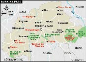
Burkina Faso (once Upper Volta) is situated at the edges of Sahel and borders with Benin, Togo, and Ghana in the south-east, with the Ivory Coast in the south, with Mali in the west, and Niger in the north. Covering twice the size of Colorado, is one of the smallest Countries of western Africa, but one of the most densely populated. The population is unequally distributed: there are long and almost desert stretches of land in the north, while the central and southern regions are full of people.
Most of the country is flat, dry, and covered with shrubs. Towards the north, getting closer to Sahara, the vegetation gives way to sandy dunes, while southwards there are forests and sugar cane fields, and in the east a sinuous plateau and green woodlands. The three main rivers of Burkina Faso, Mahoun (Black Volta), Narizon (Red Volta), and Nakambe (White Volta) water the central plateau descending towards the east and the south.
The deforestation and desertification cause drought, often combined with fast population and cattle growth and a persistent economic crisis. The result is that around the capital there is a 70 km area entirely lacking of trees. This territory has been deprived of trees by the residents, who use the timber as the main energetic resource. Only some parks and reserves have survived to this attack. If you visit the main national parks, you can still see elephants, hippos, buffaloes, antelopes, and crocodiles.
The climate of Burkina Faso is similar to that characterizing the other Countries of Sahel, with two different seasons. The dry season goes from November to May, the wet season goes from June to the end of October. The hottest period of the year is between March and June, while from December to February the harmattan winds blow, bringing dust and making the landscape foggy and not very photogenic, while people become surly and short tempered.
|