Points of Interest
Religion
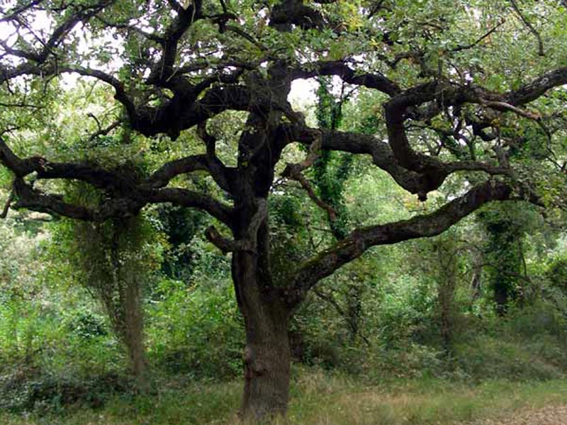
According to the tradition, in April 1001 an earl from Ariano Irpino went to Cervaro forest for a beat. At dawn, he wounded a deer, followed it to a big oak, but, when he drew closer to the tree to seize the prey, he was shrouded by "fire glares". Full of fear, he saw the Virgin Mary asking him to build a votive chapel. Meanwhile, a shepherd called Strazzacappa drew near and saw his oxen bending as if they were worshipping the oak. With great astonishment of the earl and the shepherd, a dark timber statue representing the Madonna with the infant Jesus appeared among the tree branches.
Locations
Ordona
Location of Apulia belonging to the Province of Foggia. Dating back to the Neolithic Age, it has today about 2,555 inhabitants.
- To visit: Herdonia Archaeological Area
- Events: San Leone Bishop on 22nd January; Madonna della Consolazione at Leverano; Santa Marina Feast and Festival "te li paniri" at Miggiano.
Herdonia Excavations
Ordona
excavations began on 26th November 1962. They were led by a Belgian
archaeological mission. A young archeology professor from Leuven
Catholic University, Joseph Mertens, started a research activity that
he regularly carried out, year after year. During over thirty years of
excavations carried out by the Belgian group, out of the about 22
hectares of the Roman town, an area of 4 hectares including the forum
and town center has been systematically investigated. Some
complementary investigations, on an area of over 5,000 square meters,
have been carried out in peripheral areas. Several surveys in the
surroundings of the Roman town have given the opportunity to analyze
the settlement in the territory, to reconstruct the road network, to
study the bridge on Carapelle, the waterworks, and the Roman necropolis
along via Traiana. On the initiative of prof. Mertens, now an elderly
eminent professor, ten years ago the Belgian group was replaced by an
Italian-Belgian group led by G. Volpe, with the support of the
Classical and Christian Study Department of the University of Bari and,
more recently, the Humanities Department of the University of Foggia.
In this way, the prosecution of the excavations was guaranteed: in
Herdonia one of the largest international archaeology school camps has
been organized. Hundreds of students from Italian and foreign
universities have taken part in it, also thanks to the contribution of
the Municipality of Ordona.
Troia
Troia is situated on the slope of a narrow hill (439m a.s.l.) between the sunny Tavoliere plateau and the green valleys to which the mountains of the southern Preappennino Dauno gently slope down. It has very ancient origins. Founded in the early 11th century, it incorporated in its walls a pre-existent "old town" whose origins go back to the dawn of time. At the beginning (4th-2nd millennia BC) it probably was a human settlement devoted to hunting; around the 8th century a community with evolved material and spiritual forms of life and, subsequently, from the 6th-5th century, a flourishing and refined town which could be placed in the political and cultural horizon of Magna Graecia. In the Roman Age it was called Aecae, as it is demonstrated by the works by Polybius, Strabo, and Livy, who also provide the first certain information on the history of the town. In 217, Quintus Fabius Maximus camped near Aecae, on the hill, to check Hannibal's moves from close up. In 216, after the battle of Canne, the town sided with the winner, and for this reason it will be recalled as castra Hannibalis. The Romans conquered it again in 214, without acting cruelly towards the population. Situated in the heart of a thick road network (Egnathia, Appia-Traiana, Aecae-Sipontum) connecting Rome to the East across Apulia and favored by a strategic position, the municipium flourished between the end of the Republic and the beginning of the Empire. With Septimius Severus, Aecae opened to the penetration of Christianity.
To visit:
- San Basilio Magno Cathedral
- The Treasure of the Cathedral
- Diocesan Museum
- Municipal Museum
- Historical Town Center
For information: www.comune.troia.fg.it
Lucera
Of very ancient origins, Lucera has always had a great importance; Polybius, Pliny, Eliano, Aristotle, Cicero, Caesar, Livy, and many others talk about its splendor in their works. Several research activities have revealed the presence of rests dating back to various periods: from the Neolithic Age to the Bronze Age, to the Greek period, the Dauni and Samnites period, to the Roman and imperial age. The name Lucera probably derives from the place where it was situated: luc (forest) and eri (sacred), two Etruscan roots from which Louceria and Lucera derive. Allied to Rome from the Samnite wars, it was transformed into a Latin colony, that is a town with a great autonomy, with its own magistrates, the right to mint coins, and many tax privileges. Between 1222 and 1223, Frederick II moved here 60 thousand Saracens who transformed the town into a Muslim center with mosques, harems, and Arab habits. Faithful to its Emperor who died on 13th December 1250 seven miles away from its walls, Lucera had a flourishing culture and craftsmanship until, after the battle of Benevento in 1266, it was conquered by the Angevins who changed its name in "Città di Santa Maria" (Mary's Holy Town) to remember the defeat of the Muslims.
To visit:
|
|
The texts have been taken from the web site: www.comune.lucera.fg.it
Sites of Interest in the Park Surroundings
Foggia
The ancient name "Fovea" could derive from the
reservoirs ("foveae") where wheat used to be stored. The place housed
several families escaped from Arpi, which was destroyed by the
Saracens, was called "Santa Maria de Fovea" and was situated in a
marshy area. According to the will of Robert Guiscard, in 1050 the area
underwent land reclamation activities and the settlement with its
fortifications was built. The name "Foggia" was officially established
in 1089. In 1179 the settlement was enlarged by William II the Good.
In
1223, Frederick II built a royal residence (a few ruins are still
visible), since he liked to stay in the town: he settled his court and
created the Studio, where Michele Scoto used to teach. In the Angevin
period the town flourished also from a commercial point of view. In
1447, Alfonso I from Aragon established here the so-called "Dogana
della mena della pecora" (the transhumance tax collection office). The
town suffered damages and destructions during the war between the
French and the Spanish. It was almost completely destroyed during the
1731 earthquake, but developed again with the Bourbons. In 1806,
Giuseppe Bonaparte transformed it into the capital of the province,
abolishing the "Dogana" (restored in 1817 by Ferdinand of Bourbon, and
definitively abolished in 1865).
It is the birthplace of the
composer Umberto Giordano (1867-1948). Of the royal residence built by
Frederick II in 1223, only a refined portal and an arch annexed to
Palazzo Arpi remain. Next to the Municipal Villa there is the Botanic
Garden and in the Propylaea of the Villa the Municipal Gallery of
Palazzotto dell'Arte. In viale Michelangelo there is the Provincial
Library including Biblioteca Zingarelli, Libreria Cardini, Fraccacreta
collection, and Libreria Faiella. The Jesus and Mary Church dates back
to 1510, but was rebuilt in 1738 (after the 1731 earthquake), and
preserves sculptures and paintings of various periods. Palazzo Dogana,
housing the Province Offices, also houses the Modern Art Gallery.
Loc. Arpinova - Passo di Corvo Archeological Site
The Municipality of Foggia is scattered with various archaeological sites, some of which have already been investigated, while others are under study. Among the sites that have been investigated for a long time by the Archaeological Department and the University of Foggia, there is "Passo di Corvo". Passo di Corvo is one of the characteristic entrenched villages of Tavoliere, dating back to a period between 7,000 and 5,000 years ago, and one of the few ones in the peninsula open to visitors. According to the results of the systematic excavations, the archaeologists have reconstructed a life-size settlement area surrounded by a C-shaped ditch, with hut and reconstruction of the household, agricultural, and cattle breeding activities.
- Opening times: every day 9.00 a.m. - 1.00 p.m. and 4.00 p.m. - 7.00 p.m.
- Info: Museo Civico di Foggia - Piazza Nigri - Tel. 0881/726245
Web sites: www.comune.foggia.it - www.parcoincoronata.it
Passo di Corvo
Discovered
in summer 1943 by the RAF officer John Bradford while he was observing
some aerial photos to find enemy positions, Passo di Corvo was later
explored by the same officer who returned after the war as an
archaeologist. Since he died before finishing the excavations, the
campaign was resumed in 1965 by prof. Santo Tinè on behalf of Regione
Puglia Archaeological Department.
The archaeologist, one of the top
experts of the Neolithic Age, located about one thousand villages and
explored about 200, dating them back to a period between the 7,000 and
5,000 years ago. The excavation area has a perimeter of 3,000m. Besides
the characteristic C-shaped ditches created with the aim to drain
recurrent floods, also silos, holes for poles, circular platforms,
wells drawing water from a phreatic surface, and enough rests to
reconstruct a hut have been found. Given the size and importance of the
site, an archaeological park has been created to give visitors the
opportunity to visit it together with the tour guides of the Municipal
Museum in Foggia. Together with the tour guides, visitors will have the
opportunity to observe a typical scene of daily life of a family who
lived over 6,000 years ago.


