Parco Nazionale del Gran Sasso e Monti della Laga
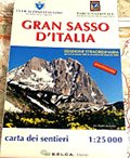
www.gransassolagapark.itGran Sasso d'Italia - Special Edition 2009 of the Map of the Trails, scale 1:25.000
Temporarily published after the 2009 earthquake
Map of the trails of Gran Sasso d'Italia 1:25.000 prepared by CAI Club Alpino Italiano and Ente Parco Nazionale del Gran Sasso e Monti della Laga - published by S.E.L.C.A.-Firenze.Since 1951, when it collaborated with President Stanislao Pietrostefani to prepare the first Map of Gran Sasso, the section of Club Alpino Italiano from L'Aquila, has been privileging and promoting over the years, in the varied context of its activities, various editions of the Map of the Massif of L'Aquila, increasingly more precise and reliable thanks to the passion and professionalism of the member Carlo Tobia.
Today it offers a new map, georeferenced, with new graphics, with a larger territory and in line with the new regulations of Gran Sasso Monti della Laga National Park.
- Author/s: C.A.I. Sezione dell'Aquila - Ente Parco Gran Sasso e Monti della Laga
- Publisher: SELCA Edizioni
- Size: 13x21cm (closed)
- Year: 2009
- Scale: 1:25.000
- Price: 10.00 €
Item temporarily sold out at Emporio dei Parchi
Item temporarily sold out at Emporio dei Parchi

Gran Sasso d'Italia - Special Edition 2009 of the Map of the Trails, scale 1:25.000
© 2024 - Ente Parco Nazionale del Gran Sasso e Monti della Laga


